
According to the real-time data from the India Meteorological Department (IMD), June ended with a rainfall deficit of 8% over India. June witnessed sluggish Monsoon activity across the country, however, the Bay of Bengal Monsoon branch led to heavy spells of rainfall in North-east India. The first half of June recorded a large deficit in rainfall, with Central India recording a deficit of -20% as on July 4. Though the heavy rainfall events of North-east India has somewhat made up for the All-India averaged rainfall, the deficit over Central India is unusual.
The see-saw relationshiop between June and September rainfall over India.
The past decade has witnessed certain years which had large intra-seasonal fluctuations in rainfall. For example, 2012, 2014 and 2019 witnessed large deficits in June rainfall. The rainfall during September in 2014 and 2019 was above normal. This is indicative of a “see-saw” in the rainfall relationship (RR) between June and September. Therefore, I took a long record of rainfall from IMD and IITM over India to check whether such a see-saw relation has happened in the past. The plot below shows the 11-year running correlations between the June and September Rainfall percentage departures.
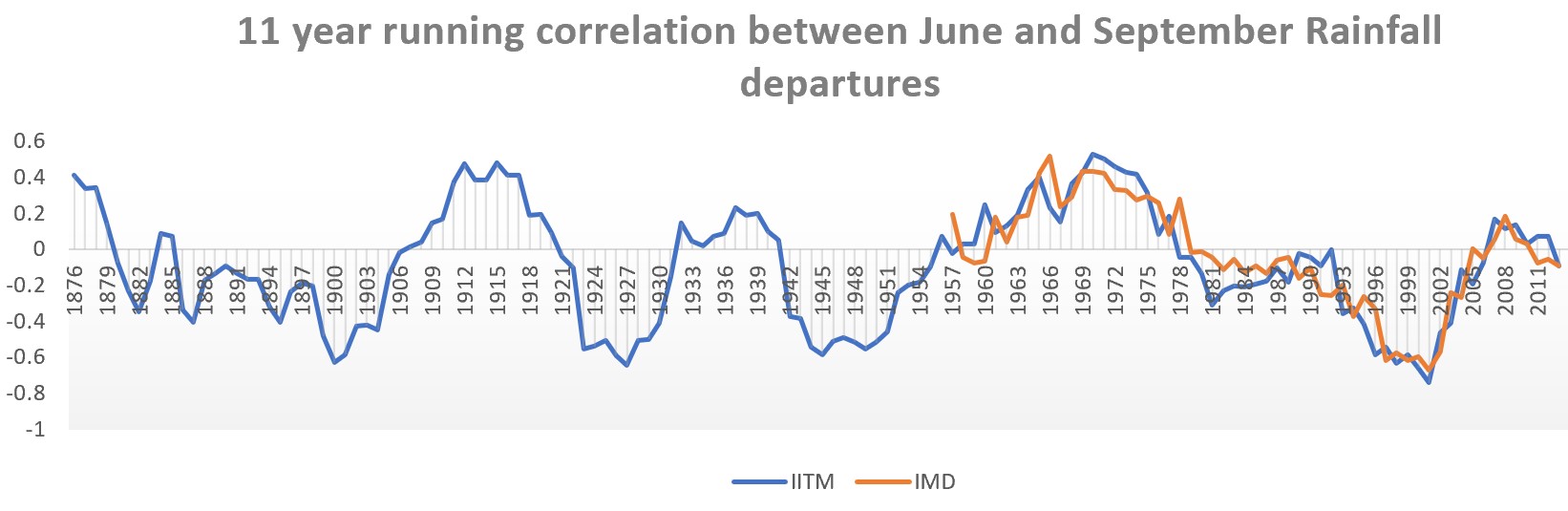
It is evident that epochal fluctuations in RR have occurred in the past. There are certain periods when the phase relationship between June and September rainfall was same, and others where it was opposite. Until recently, we were in a negative phase, where deficient June would end up with a excess rainfall September.
Do we need to worry?
Deficient rainfall in pockets across the coutry have left the farmers worried. What is in store for the rest of the season? Let us ponder over this question for a moment. La-Nina conditions are prevailing in the Pacific. The SST anomalies were the coolest during May this year, out of the eight “double-dip” La-Nina events that have occured in the past. The model forecasts are indicative of slight weakening of La-Nina conditions during boreal summer, and then strengthening again. Indian Ocean conditions indicate development of negative IOD type conditions, and models indicate that neutral/negative IOD conditions will prevail during July-August-September. The plots below show a scatter of June vs seasonal mean (JJAS) departures as a function of ENSO conditions and IOD conditions.


It is interesting to note from these figures that large June deficit (<-10%) years leading to below normal monsoon have always been accompanied by El-Nino except for 1979 & 2009. La-Nina years never coincide with a June deficit less than -10% except for 1988. Small June deficits (~-10%) always end up in normal/above-normal JJAS monsoon. Almost all negative IOD conditions during JJA have resulted in normal/excess monsoon, except for 1965. Small June deficits (~-10%) always end up in normal/above-normal JJAS monsoon, almost always associated with neutral/negative IOD. Therefore, historically speaking, the chances of this year ending as a below-normal monsoon are less. The long range forecasts from IMD and other centres also indicate positive rainfall anomalies over India.
Fingers crossed! And stay-tuned for other interesting blogs on my page.